
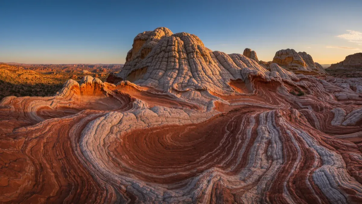
Hiking to The Wave requires a permit from the Bureau of Land Management before you set foot on the trail — roughly 64 people per day are allowed into Coyote Buttes North, awarded by an online lottery run through recreation.gov and a smaller next-day walk-in draw, per BLM permit information current as of 2025. The hike itself is modest on paper: about 6 miles round trip and a few hundred feet of gain from the Wire Pass Trailhead, but it is unmarked, trail-less cross-country navigation over sandstone, with no water and no shade.
The Wave is a swirling, wave-shaped trough of Navajo sandstone on the Arizona-Utah line inside the Paria Canyon-Vermilion Cliffs Wilderness, and the BLM caps visitation to protect the fragile aeolian surfaces. This guide covers the permit system, the road, the navigation, and the conditions that turn a bucket-list walk into a rescue — because the area's incident record is real, and the managing agency publishes the warnings to match.
How does The Wave permit lottery work?
The BLM splits the daily Coyote Buttes North quota between an advance online lottery on recreation.gov, where applicants pick a date window months ahead and winners are drawn well before the trip, and a next-day walk-in lottery run from the BLM's field office in Kanab, Utah, for the remaining slots, per the BLM's published permit process as of 2025. An application fee applies when you enter, and permit winners pay a per-person recreation fee; the current amounts live on the BLM and recreation.gov pages, and both have been revised over the years — check before you apply. Every member of the group, including dogs, counts against the quota, and the permit is specific to the date on it; rolling it to another day is not an option.
Odds swing wildly. Popular spring and fall weekends draw hundreds of applicants for a few dozen slots, while midweek winter dates can succeed on a single entry. The honest strategy: apply for winter and midweek dates, keep your group small, and treat the walk-in draw as a bonus rather than a plan.
How hard is the hike itself?
The route from Wire Pass Trailhead crosses about 2.5 miles of open sage flat and sandy wash before climbing through a sandstone pass into Coyote Buttes North, where the wave-shaped formation sits maybe a half-mile further among the fins and dunes, per BLM route descriptions. There is no maintained trail, no cairns, and no signage inside the permit area — the BLM hands permit holders a map and photo guide, and recommends a GPS unit or loaded track. Total round trip runs about 6 miles with modest elevation change, but sand, slickrock ledges, and route-finding make it slower than the numbers suggest; most parties take three to five hours in and out.
Do you really need navigation skills?
Yes, and the incident log explains why. The BLM's safety guidance for Coyote Buttes repeatedly notes that visitors get lost every year in terrain where every direction looks similar and heat exhaustion kills. Carry a GPS with a downloaded track or the BLM's route description, plus a paper map as backup, and set your waypoints at the pass and the trailhead before you leave the car. If you are navigating by photographs alone, you are doing the thing the agency asks you not to do.
When should you go?
Spring and fall are the sweet seasons: lottery odds are worse, but temperatures sit in the comfortable range and daylight is generous. Summer is the dangerous season — high temperatures in the Coyote Buttes area routinely pass 100°F, the BLM's own heat warnings are blunt, and a six-mile unshaded walk in that heat has proven fatal. Winter brings cold mornings, short days, and the possibility that snow makes the sandstone slick; it also brings the best lottery odds of the year. Whenever you go, start early: the two-plus miles of open sand are far kinder before noon.
Related stories: What to Know Before You Hike to Havasu Falls · What to Know Before You Sea Kayak the Apostle Islands.
What about the road to the trailhead?
The Wire Pass Trailhead sits off House Rock Valley Road (BLM Road 1065), a dirt road between U.S. 89 and U.S. 89A east of Kanab. It is usually passable by passenger cars in dry weather, but the BLM warns it becomes deeply muddy and effectively impassable after rain or snow — and clay mud there will stop anything short of a high-clearance 4x4. Check the current road status on the BLM Arizona Strip district page the day before, and never gamble a flight home on a dirt road after a storm. Bring a full-size spare; sharp rock is part of the package.
| Fact | Detail (per BLM, as of 2025) |
|---|---|
| Daily quota | About 64 people per day, split between advance online lottery and next-day walk-in draw |
| Where permits come from | recreation.gov (advance) and the BLM office in Kanab, Utah (next-day) |
| Round trip | About 6 miles from Wire Pass Trailhead, unmarked route |
| Water and shade | None — carry everything |
| Best season | Spring and fall; winter has the best permit odds |
| Access road | House Rock Valley Road (BLM 1065), dirt, impassable when wet |
What rules protect the place once you are in?
The permit terms are strict and worth reading before your date. No drones, no camping inside Coyote Buttes North, dogs allowed only on the permit with their own fee and under control, and no climbing on the fragile sandstone fins. Foot traffic sticks to sand where possible — the BLM asks visitors to avoid stepping on the living biological crust between the wash and the slickrock, and the Leave No Trace habit of walking single file in existing tracks applies. This is a geologic formation that took 190 million years to make and a footprint can outlast your visit; the quota exists because the surface cannot absorb crowds.
Permit rules, fees, and road status change — confirm all three on the BLM's Coyote Buttes pages shortly before your date.
Route facts
- Destination: The Wave, Coyote Buttes North, Paria Canyon-Vermilion Cliffs Wilderness, Arizona-Utah border
- Distance: about 6 miles round trip from Wire Pass Trailhead; minor elevation change (per BLM route descriptions)
- Difficulty: moderate walking, serious navigation and heat exposure; unmarked route
- Permit: required for all entry, advance lottery via recreation.gov plus next-day walk-in draw; fees current as of 2025 — check the BLM for amounts
- Season: year-round quota; spring and fall most comfortable, winter easiest to draw
- Managing agency: Bureau of Land Management, Arizona Strip Field Office
- Conditions change — check road status and weather before you go
Frequently asked questions
Can you hike to The Wave without a permit?
No. Entry into Coyote Buttes North without a permit for that date is a federal violation, and rangers patrol the area, per BLM rules. The nearby Wire Pass-to-Buckskin Gulch route shares the trailhead and requires only a day-use fee, which is why it is the standard substitute.
What are the odds of winning the lottery?
They depend entirely on the date: prime spring and fall weekends can draw hundreds of applications for a few dozen slots, while midweek winter dates often succeed on first entries, per the BLM's published application statistics. Apply off-season and midweek, and keep your group small.
Is the walk-in lottery still the way to get a permit?
It is one of two ways: a portion of each day's quota goes to a next-day walk-in drawing run from the BLM office in Kanab, per the agency's permit page as of 2025. Confirm the current split and entry procedure before your trip, because the system has been revised more than once.
How dangerous is the heat at Coyote Buttes?
Dangerous enough that the BLM posts explicit heat warnings for the area, where summer high temperatures commonly exceed 100°F with no shade or water. Fatal heat incidents have occurred on this route. If you hold a summer permit, start before dawn, carry more water than seems reasonable, and be ready to turn around early.